
Bayannur City
Bayannur CityBayannur (also known as Bashi or Bameng) is a prefecture-level city in the Inner Mongolia Autonomous Region of China. In Mongolian, "Bayannur" means "rich lake." Located between 40°13'–42°28'N and 105°12'–109°53'E, it is situat
Bayannur City
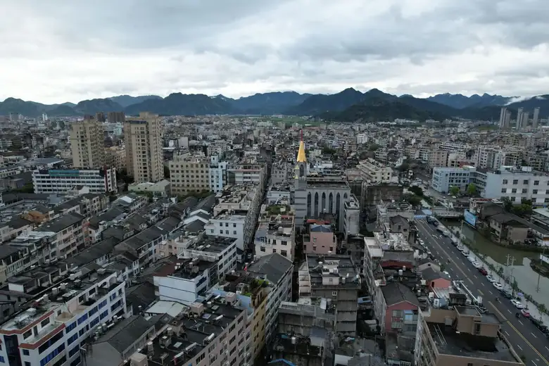
Bayannur (also known as Bashi or Bameng) is a prefecture-level city in the Inner Mongolia Autonomous Region of China. In Mongolian, "Bayannur" means "rich lake." Located between 40°13'–42°28'N and 105°12'–109°53'E, it is situated in western Inner Mongolia, bordering Alxa League, Ordos, and Baotou to the west, south, and east, and Mongolia to the north, with a total area of 65,000 square kilometers. The city administers seven banners, counties, and districts. As of end-2024, the resident population was 1.4894 million, with an urbanization rate of 62.74%. The terrain features the Urad Grassland in the north, the Yinshan Mountains across the center, and the Hetao Plain in the south. The Yellow River flows through the city with numerous lakes. Bayannur has a mid-temperate continental monsoon climate.
Human settlement dates back to primitive society. From the pre-Qin period through the Ming dynasty, the region was alternately ruled by central Chinese and northern nomadic regimes. In 1956, the Bayannur League was established; in 2003, it was converted to a prefecture-level city. Bayannur is a major national grain, oil, and meat sheep production base, with quality agricultural products exported to 93 countries. The city was designated a National Garden City in 2017 and a National Hygiene City in 2021. In 2025, GDP reached 127.76 billion yuan (approximately US$17.5 billion), up 4.5%.
Name Evolution
The area historically lacked a unified name. After the Yellow River shifted southward during the Northern Wei dynasty, it became known as the "Rear Loop of the Yellow River." In 1954, Suiyuan Province was merged into Inner Mongolia, and the area was designated the Hetao Administrative Region. In 1956, the Bayannur League People's Committee was established in Bayanhot, giving rise to the name "Bayannur League" (abbreviated "Bameng"). In 2003, the league was converted to a city, establishing Bayannur City and Linhe District (abbreviated "Bashi").
Historical Evolution
Pre-Qin Period
Human habitation north of the Yinshan Mountains dates back to primitive society. During the Warring States period, the south belonged to the Zhao state's Yunzhong Commandery, while the north was Xiongnu grazing land.
Qin to Northern and Southern Dynasties
In 221 BCE, the area belonged to Jiuyuan Commandery. In 211 BCE, Qin Shi Huang relocated 30,000 households to the Beihe River (today's Wujia River) for agricultural development. During the Western Han, the area south of the Wujia River was divided between Wuyuan and Shuofang commanderies. During the Northern Wei (386–534 CE), the Yellow River shifted southward, and the former riverbed became the Wujia River, giving rise to the "Yellow River Rear Loop" concept.
Sui, Tang to Song and Yuan
In 585 CE, the Sui established Fengzhou to govern the Hetao area. In 647 CE, the Tang established the Yanran Protectorate. During the Five Dynasties period (907–979), the Liao controlled the area. In 1034, the Western Xia established the Black Mountain Weifu Military Commission in present-day Urad Rear Banner. Under the Yuan dynasty (c. 1330), the area was administered by the Gansu Branch Secretariat.
Ming and Qing
During the early Ming, the area south of the Yinshan was under Ningxia Guard (Shaanxi), while the Urad banners were under Dongsheng Guard (Shanxi). After 1462, Mongol tribes entered the Hetao region. In 1697, the Qing incorporated the Dengkou area into the Alxa Khoshut Banner. In 1903, Wuyuan Department was established.
Republic of China
In 1914, the area was placed under the Suiyuan Special Administrative Region. In 1939, the Suiyuan provincial government relocated to Shanba Town (present-day Hangjin Rear Banner) after the fall of Hohhot, making it a key military center on the northwest anti-Japanese front. On September 19, 1949, the area was peacefully liberated.
After the Founding of the People's Republic of China
In 1956, the Bayannur League was established. In 1958, the league government relocated to Dengkou County. In 2003, the State Council approved conversion from league to city. Bayannur City now administers seven banners, counties, and districts — Hangjin Rear Banner, Urad Rear Banner, Urad Middle Banner, Urad Front Banner, Wuyuan County, Dengkou County, and Linhe District — plus one national-level economic development zone, one national agricultural high-tech demonstration zone, and Ganqimaodu Port.
Natural Geography
Location
Bayannur is on China's northern frontier in western Inner Mongolia, sharing a 369-kilometer border with Mongolia to the north. Total area: 65,000 square kilometers.
Climate
Mid-temperate continental monsoon climate with abundant sunlight, low precipitation, and large temperature variations. Annual average temperature: 3.7–7.6 degrees Celsius. Annual sunshine: 3,110–3,300 hours — among China's richest solar energy regions. Frost-free period: 126 days. Annual precipitation averages only 188 mm, while evaporation reaches 2,032–3,179 mm. Average wind speed: 2.5–3.4 m/s.
Geology
The city lies on the Yinshan-Tianshan tectonic belt, straddling the North China Platform and the Inner Mongolian Paleozoic fold zone, hosting the famous Langshan-Zhartai Mountain polymetallic metallogenic belt.
Topography
Three terrain types: northern plateau (Urad Grassland, 1,000–1,800 m), central mountains (Langshan 280 km, Ula Mountain peak 2,334 m, forest coverage 27.75%), and southern Hetao Plain (1,018–1,050 m), known as the "Jiangnan beyond the Great Wall" for its fertile irrigated land. The Ulan Buh Desert in the west is one of China's eight major deserts.
Hydrology
The Yellow River flows 333.5 km through the city with an average annual flow of 31.5 billion cubic meters. Over 300 lakes total 47,000 hectares, with Ulansuhai Lake being the largest at 30,000 hectares. The Hetao Irrigation District, centered on the Sanshenggong Water Conservancy Hub, irrigates over 10 million mu (approximately 667,000 hectares).
Soil
Types include light chestnut calcic soil, irrigated silted soil, and saline soil. pH averages 8.55, indicating significant salinization.
Natural Disasters
Main disasters: floods, droughts, and sandstorms. Between 2008–2012, floods affected 897,000 hectares of crops and caused 940 million yuan (approximately US$129 million) in losses. In 2018, five floods caused 4.486 billion yuan (approximately US$615 million) in direct losses. Drought is chronic in mountainous pastoral areas (precipitation under 200 mm, evaporation over 2,000 mm). Sandstorms are frequent — 11 major dust events in spring 2024 alone — due to the city's position downwind of the Gobi and several deserts.
Natural Resources
Water Resources
Total water resources: approximately 5.8 billion cubic meters. Per capita availability: 600 cubic meters (30% of national average), indicating structural scarcity. In 2022, total consumption was 5.003 billion cubic meters, with agricultural use at 88%.
Land Resources
Total area: 64,400 square kilometers. Arable land: 905,100 hectares (13.58 million mu). Grassland: 3.898 million hectares (58.47 million mu). Forest: 516,700 hectares (7.75 million mu).
Mineral Resources
46 mineral species identified on the Langshan-Zhartai Mountain polymetallic belt. Pyrite ranks first regionally. Proven crystalline graphite: 92.99 million tons. Petroleum: 252 million tons. Zinc: 10.61 million tons. Lead: 3.22 million tons. Copper: 1.69 million tons. Iron: 706 million tons. Coal: 3.21 billion tons (primarily lignite).
Biodiversity
106 protected animal species (86 national: 21 Class I, 65 Class II), including Pallas's fish eagle and saker falcon. Ulansuhai Lake hosts 258 bird species (95% of city total). Eleven protected plant species include facai, licorice, and desert broomrape (Cistanche) — the latter a nationally protected geographical indication product nicknamed "ginseng of the desert."
Nature Reserves
Six provincial-level or above nature reserves (2 national, 4 provincial).
Renewable Energy
Abundant wind and solar resources: average wind speeds over 8 m/s, annual sunshine approximately 3,200 hours. Installed new energy capacity: 9.556 million kW (2023).
Administrative Divisions
Seven banners, counties, and districts — Linhe District, Urad Front Banner, Urad Middle Banner, Urad Rear Banner, Wuyuan County, Hangjin Rear Banner, and Dengkou County — plus one national-level economic development zone, one national agricultural high-tech demonstration zone, and Ganqimaodu Port. Municipal seat: Linhe District.
Politics
The municipal government is headquartered in Linhe District, operating under the leadership of the Communist Party of China.
Population
Population Size
End-2024 resident population: 1.4894 million, urbanization rate 62.74%. Age structure: 11.0% aged 0–14, 72.0% aged 15–64, 17.0% aged 65+. Sex ratio: 104.48. Natural growth rate: -5.65 per mille.
Ethnic Groups
Han Chinese 92.7%, Mongols 5.5%, other minorities 1.8%. 39 ethnic minorities with a broad-dispersion, small-concentration pattern. 124 gacha (villages) with 45 minority-concentrated villages.
Language
Local Mongolian dialect: Chahar-Xi-Urad branch of Inner Mongolian dialect. Chinese dialect: Jin language's Dabao and Wutai subgroups.
Religion
Multi-religion region practicing Buddhism, Islam, and Christianity. The Agui Temple is the only Nyingma sect Tibetan Buddhist temple in Inner Mongolia. Other Tibetan Buddhist temples include Qianli Temple and Xire Temple. Chinese Buddhist temples include Ganlu Temple and Baolian Temple. Islam is primarily practiced by the Hui people.
Economy
Overview
Major national grain and oil base, China's largest organic raw milk, sunflower seed, and dehydrated vegetable production base, and second-largest tomato processing base. Products exported to 93 countries, trade volume first in the region for 11 consecutive years.
2024 GDP: 124.23 billion yuan (approximately US$17.0 billion), up 5.7%. Sector contributions: primary 32.86 billion, secondary 36.24 billion, tertiary 55.13 billion yuan. Per capita disposable income: 36,113 yuan (approximately US$4,950). Urban-rural income ratio: 1.54, below the national 2.34. Public budget revenue: 8.62 billion yuan (approximately US$1.18 billion), up 7.6%. Fixed asset investment grew 22.4%, driven by new energy (35.8% of total) and infrastructure (33.9% growth).
Primary Industry
Located on the 40 degrees north golden crop belt. 2024 agricultural output: 55.04 billion yuan (approximately US$7.54 billion), up 6.0%. Grain output: 5.87 billion jin (2.935 million tons), above 5 billion jin for seven consecutive years. Sheep population exceeded 22 million, ranking first regionally. Milk production: 1.489 million tons. The "Tianfu Hetao" brand won multiple national awards. 2025 agricultural exports: 8.63 billion yuan (approximately US$1.18 billion), 62% of the region's total, first for 17 consecutive years.
Secondary Industry
Centered on mining and manufacturing. 2024 above-scale industrial value-added grew 7.3%, with mining up 19.3% (18 months of double-digit growth). Crude oil and power generation increased 64.4% and 14.0% respectively. Small and micro enterprises (313 of 348 firms) contributed value-added growth of 17.4%.
Tertiary Industry
Dominated by services and tourism. Bayannur integrates culture and tourism through events like the Urad International Camel Culture Festival. 2024 service sector contributed 42.3% of growth. Retail sales: 24.25 billion yuan (approximately US$3.32 billion), up 3.5%. Foreign trade: 44.51 billion yuan (approximately US$6.10 billion). Ganqimaodu Port processed 40.72 million tons of cargo, including 39.21 million tons of imported coal.
Economic Functional Zones
The Bayannur Economic and Technological Development Zone (national-level since 2012) hosts 37 high-tech enterprises with 33 invention patents. The National Agricultural High-Tech Industry Demonstration Zone (est. 2022) focuses on ecological agriculture in the Hetao Irrigation District, serving as a Belt and Road agricultural cooperation hub.
Social Affairs
Education
355 schools with 194,000 students and 23,000 faculty (2023). Hetao University is a comprehensive applied undergraduate institution. Inner Mongolia Art Vocational College offers higher education in fine arts.
Healthcare
1,749 medical institutions with 14,993 health professionals and 12,148 beds. Bayannur Municipal Hospital (est. 1958) is a tertiary Grade A hospital serving over 1.5 million residents.
Science and Technology
261 valid invention patents (1.7 per 10,000 population). 2023 patent grants: 859. Technology contract transactions: 99.23 million yuan (approximately US$13.6 million).
Media
One municipal broadcasting station, six county-level convergence media centers. Radio and TV coverage: 99.88% each. Bayannur Daily annual circulation: 707,000 copies.
Culture
7 performing arts troupes, 8 cultural centers, 8 public libraries, 13 museums. The Hetao Culture Museum (29,000 square meters) displays nearly 5,000 artifacts across seven thematic units.
Sports
6,071 registered social sports instructors, 5,482 venues (5.494 million square meters, 3.083 square meters per capita). 2023 medals: 76 gold, 75 silver, 97 bronze.
Environmental Protection
2023 forestry ecological construction: 463,000 mu (approximately 30,900 hectares). Forest coverage: 6.7%. The city is part of the "Three Zones, Four Belts" pattern, with areas in the Northern Sand Prevention Belt and Yellow River Key Ecological Zone.
Social Security
1.125 million pension insurance participants (2023). Subsistence allowances: 94.55 million yuan (approximately US$13 million) for 13,806 urban recipients and 281.74 million yuan (approximately US$38.6 million) for 62,016 rural recipients. Medical assistance: 118.58 million yuan (approximately US$16.3 million), benefiting 179,000 person-times.
Transportation
Overview
Key Belt and Road node city at the intersection of China's "Ten Vertical, Ten Horizontal" transportation network. Only Inner Mongolian city with "two corridors and one channel." G6 Beijing-Tibet and G7 Beijing-Xinjiang expressways intersect here, with 12 national/provincial highways. Tianjitai Airport serves 8 cities.
Highways
386 km expressways, 470 km first-class, 1,314 km second-class, 20,041 km rural roads, totaling 23,000 km (density: 35.6 km per 100 square kilometers). 2016–2020 cumulative: 38.84 million passengers, 458.09 million tons freight.
Railways
Baotou-Lanzhou Railway traverses the city, plus Linhe-Hami Railway and coal transport lines. Baotou-Yinchuan High-Speed Railway's Bayannur section has five new stations (Linhe West largest: 7,998.6 square meters, 5 platforms, 12 tracks). On December 23, 2025, the Baotou-Huinong segment opened, bringing Bayannur into the high-speed rail era.
Aviation
Tianjitai Airport (4C, opened 2011): 2,600-meter runway, 6 parking positions. 2023: 5,433 flights, 361,857 passengers. Urad Middle Banner Airport (opened 2016): first general aviation airport in North China with short-haul transport capability.
Public Transportation
48 rural bus routes and 1 intercity route repurchased (2023). Government promoting integrated passenger-cargo-mail services with 620 new village delivery points.
Culture and Humanities
Overview
Rich heritage blending Yellow River, farming, grassland, and frontier fortress cultures over millennia. Historical sites include Yinshan rock art, Qin-Han Great Wall, and Jilu Fortress. Notable stories include Meng Tian's land reclamation and Wang Zhaojun's frontier departure. Representative songs: "Hongyan" (Swan Goose) and "Tianfu Hetao."
Cuisine
Renowned for flour-based foods and lamb dishes — core of Hetao cuisine. Signature dishes: hand-grabbed mutton, roasted whole lamb, "Hetao Hard Four Plates" (braised pork, crispy chicken, meatballs, steamed lamb — intangible cultural heritage), cold skin noodles, and braised pickled cabbage. Bameng cold skin noodles, made from premium Hetao wheat flour, are also called "Zhaojun skin" after the legendary Wang Zhaojun.
Customs
Folk activities include the Naadam festival, River Lantern Festival, and Nine-Bend Yellow River Lantern Fair. Traditional Mongol sports: camel polo, horse racing, boke (wrestling), and archery. Naadam ("entertainment" in Mongolian) is an annual harvest festival dating to the Mongol Empire (1206). Spring Festival customs include "prosperity fires." Fire worship symbolizes sanctity and prosperity. Naoge performances feature mythological stories with children atop iron frames carried by adults. Boke requires participants in powers of two, no weight classes, no time limits.
Art
Traditional folk song styles: Pashandiao (mountain tunes), Errentai (two-person theater), and Urad folk songs — representing Mongol-Han musical fusion in the Hetao region.
Historical Sites
7 national-level and 63 regional-level protected sites. Yinshan rock art (over 50,000 paintings) is one of the world's richest collections and one of China's seven major rock art treasures. Four Great Wall sections span 1,007 km — 5% of China's total. Several sections were listed as nationally important in 2020.
Intangible Cultural Heritage
4 national-level, 44 regional, and 303 municipal heritage items (2022). National items: Pashandiao, Urad folk songs, Mongol camel polo, and Urad copper-silver craftsmanship. Other notable heritage: Hetao dough sculpture, Urad traditional attire, and the Shaga (ankle bone) game. Errentai theater evolved through six stages from casual entertainment to professional theater, blending Shanxi, Shaanxi, and Mongol musical traditions.
Scenic Spots
37 A-level tourist attractions (8 at 4A level), blending natural scenery with cultural heritage across millennia of Yellow River, grassland, farming, and frontier cultures.
Important Scenic Spots
Key attractions: Yellow River Hetao Cultural Tourism Area (4A, 6.03 square kilometers in Linhe District), Ulansuhai Lake (one of China's eight major freshwater lakes, Ramsar wetland, 293 square kilometers), Ulan Buh Desert Lake Tourism Area (3A), Bayannur National Geopark (mountains, deserts, lakes with dinosaur fossils), Ula Mountain National Forest Park (largest of China's first 45 national forest parks, 1.4 million mu), Yellow River Water Conservancy Culture Museum, and Sanshenggong National Water Conservancy Scenic Area (Asia's largest single-type plain irrigation dam).
External Exchange
Important gateway connecting China and Mongolia via Ganqimaodu Port. The city actively participates in Belt and Road Initiative cooperation and regional economic integration.
Important Honors
National Garden City (2017), National Double Support Model City (2020), National Hygiene City (2021).
Travel information can change. Check current opening hours, reservations and entry requirements before you travel.
Traveller discussion
Start the conversation with a helpful tip or a question.