
Hainan Tibetan Autonomous Prefecture
Hainan Tibetan Autonomous PrefectureHainan Tibetan Autonomous Prefecture, abbreviated as "Hainan Prefecture," is under the jurisdiction of Qinghai Province, with its capital seated in Gonghe County. It is one of the eight prefecture-level a
Hainan Tibetan Autonomous Prefecture
Hainan Tibetan Autonomous Prefecture, abbreviated as "Hainan Prefecture," is under the jurisdiction of Qinghai Province, with its capital seated in Gonghe County. It is one of the eight prefecture-level administrative divisions of Qinghai. It borders Haidong City and Huangnan Tibetan Autonomous Prefecture to the east, Haixi Mongolian and Tibetan Autonomous Prefecture to the west, Guoluo Tibetan Autonomous Prefecture to the south, and faces Haibei Tibetan Autonomous Prefecture across Qinghai Lake to the north. The terrain is predominantly mountainous, surrounded by mountains with a basin in the center, characterized by a typical plateau continental climate. The total area is 44,500 square kilometers. As of November 2025, Hainan Tibetan Autonomous Prefecture administers 5 counties. As of the end of 2025, the permanent resident population was 450,200. In December 1953, Hainan Tibetan Autonomous Region was established. In July 1955, it was renamed Hainan Tibetan Autonomous Prefecture. The prefecture is home to major scenic spots and natural landscapes including the national-level scenic area Qinghai Lake, Riyue Mountain, Daotang River, Longyang Gorge Hydropower Station, Heyin Town, the sacred mountain and ancient temple Saizong Temple, Fusi Ancient City, Tongde Hebei Forest Farm, and Zhihai Snow Mountain. The prefecture has a highway network of "four horizontal and three vertical" routes, with National Highways 109 and 214 and the provincial Xijiu Line as the main framework, connected by prefecture and county local roads. In 2025, the gross regional product was 24.626 billion yuan, an increase of 4.9% over the previous year at constant prices.
History
Before the Qin and Han Dynasties, Hainan Prefecture belonged to the Qiangrong territory. The ancestors here had already entered the Chalcolithic period, with primitive gathering and agriculture.
During the early Western Han Dynasty (202 BC–220 AD), the Hainan area had been incorporated into the central dynasty's administrative system. In the second year of the Shenjue era (60 BC), Jincheng Commandery established Heguan County, governing present-day Guide and eastern Gonghe areas, under the jurisdiction of the Qiang Colonel Protector. In the fourth year of the Yuanshi era (4 AD), Wang Mang established Xihae Commandery, whose territory included most of present-day Gonghe and Xinghai counties.
After the Eastern Jin Dynasty, present-day Guide and Gonghe were governed by Former Liang, Later Liang, Northern Liang, and Tuyuhun respectively. In the fifth year of the Jiande era (576 AD), Northern Zhou recovered the area south of the Yellow River and established Guozhou, governing present-day Guide, Guinan, and other areas.
In the third year of the Daye era of the Sui Dynasty (581–618) (607 AD), Guozhou was renamed Jiaohe Commandery, and present-day Guide and Guinan counties became its territories. In the fifth year of the Daye era (609 AD), the Sui conquered Tuyuhun and newly established Heyuan and Xihae commanderies, governing the area south of Daba in present-day Xinghai County, Tongde, and Gonghe.
In the thirteenth year of the Tianbao era of the Tang Dynasty (618–907) (754 AD), the Longyou Military Commissioner Geshu Han recovered the Nine Curves territory and established Jiaohe Commandery and Wanxiu Army south of the Yellow River. In the first year of the Zhide era (756 AD), the territory fell to Tubo.
In the second year of the Yuanfu era of the Northern Song Dynasty (960–1279) (1099 AD), the Tsongkha leader Xibawen occupied present-day Guide and built Xige City. In the second year of the Daguan era (1108 AD), the Song army recovered Xige City and reorganized it into Jishi Army, governing present-day Guide County and areas to its east.
In the first year of the Shaoxing era of the Southern Song Dynasty (1127–1279) (1131 AD), the Jin Dynasty (1115–1234) captured Jishi Army, and the southeastern area of present-day Hainan came under Jin's jurisdiction.
In the eighth year of the Zhiyuan era of the Yuan Dynasty (1271–1368) (1271 AD), Guide Zhou was established in present-day Guide, under the jurisdiction of the Tibetan Pacification Commissioner's Command. In the twenty-third year (1286 AD), Guide Zhou was placed under the jurisdiction of Hezhou Route of the Shaanxi Branch Secretariat.
In the third year of the Hongwu era of the Ming Dynasty (1368–1644) (1370 AD), Guide Zhou was renamed Guide Zhou. In the eighth year (1375 AD), it was changed to Guide Guard Thousand Household Office, subordinate to Hezhou Guard of Lintao Prefecture. In the tenth year (1377 AD), it was renamed Guide Zhou again, governing present-day Guide and parts of Guinan. Other areas of present-day Hainan were under the jurisdiction of the Doken Regional Military Commission.
In the sixth year of the Shunzhi era of the Qing Dynasty (1644–1912) (1649 AD), the Qing established Guide Subdistrict in present-day Guide County. In the second year of Yongzheng (1724 AD), the area north of the Yellow River in present-day Guide came under Xining County. That year, the Imperial Commissioner's Office for Mongolian and Tibetan Affairs was established in Guide, later moved to Xining. In the fourth year of Yongzheng (1726 AD), Guide Subdistrict was transferred to Lintao Prefecture. In the third year of Qianlong (1738 AD), to Xining Prefecture. In the twenty-sixth year (1761 AD), Guide was renamed Guide and established as a county. In the fifty-sixth year (1791 AD), Guide Subprefecture was established with a Prefect for Managing Tribal Affairs.
In 1913 (the second year of the Republic of China), Guide Subprefecture was converted to a county under Xining Circuit of Gansu. In July 1929, Gonghe County was established. In 1935, Tongde County was established. In 1939, Daba Administrative Bureau was established. In 1940, the Seventh Inspectorate was established. In 1943, Daba was converted to a county. In 1946, the Inspectorate was abolished.
On September 18, 1949, Guide County was liberated. On September 25, Gonghe was liberated. On September 27, Xinghai was liberated. In 1951, the Tongde Tibetan Autonomous Region was established. In 1952, the Gonghe and Xinghai Tibetan Autonomous Regions were established. In 1953, the Guinan Tibetan Autonomous Region was established. On December 6, 1953, Hainan Tibetan Autonomous Region was established, governing 5 counties. On July 28, 1955, it was renamed Hainan Tibetan Autonomous Prefecture. In 1978, the Longyang Gorge Working Committee was established (county-level), bringing the total to 6 counties. In 2001, it was abolished, and the prefecture returned to 5 counties: Gonghe, Guide, Tongde, Guinan, and Xinghai.
Administrative Divisions
As of November 2025, Hainan Tibetan Autonomous Prefecture administers 5 counties: Gonghe County, Guide County, Guinan County, Tongde County, and Xinghai County. The Prefecture People's Government is seated in Qabqa Town, Gonghe County.
Geographical Environment
Location and Boundaries
Hainan Tibetan Autonomous Prefecture is located in eastern Qinghai Province, named for being south of Qinghai Lake, China's largest saltwater lake. Known as the "Gateway to Tibet from Qinghai," it is the eastern gateway to the Qinghai-Tibet Plateau. It borders Haidong City and Huangnan Tibetan Autonomous Prefecture to the east, Haixi Mongolian and Tibetan Autonomous Prefecture to the west, Guoluo Tibetan Autonomous Prefecture to the south, and Haibei Tibetan Autonomous Prefecture across Qinghai Lake to the north. The geographical coordinates are 98°55'–105°50' east longitude and 34°38'–37°10' north latitude, spanning 260 kilometers east to west and 270 kilometers north to south, with an area of 44,500 square kilometers, accounting for 6.18% of Qinghai Province's total area.
Topography and Landforms
The terrain is predominantly mountainous, with mountains surrounding a central basin, interspersed with plateau hills and river terraces. The average elevation is above 3,000 meters, with the highest point at Suigen'ergang at 5,305 meters and the lowest at 2,168 meters. The landscape features alternating basins and mountain ranges from northwest to southeast: Qinghai Lake Basin, Qinghai South Mountains, Gonghe-Guide Basin, Heka Mountains, Xinghai-Tongde Basin, and Mogu Mountain-Sangchigang Mountains. Mountains account for 42.3% of the total land area, hills 11%, and mid-elevation plains and terraces 46.7%.
Climate
Hainan has a typical plateau continental climate, characterized by thin atmosphere, aridity, long sunshine hours, strong solar radiation, cold temperatures, small annual but large diurnal temperature ranges. Spring is dry and windy, summer short and cool, autumn wet and rainy, and winter long and dry. The average temperature ranges from 7°C in the lower Yellow River valley to below 0°C above 3,400 meters and below -4°C above 4,000 meters. Annual precipitation ranges from 300–360 mm in the Gonghe Basin to 400–500 mm in the south and Qinghai Lake area.
Hydrology
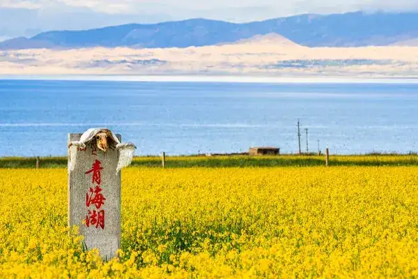
Qinghai Lake, located in the northern part of the prefecture, is China's largest inland plateau brackish lake, with a surface area of 4,573 square kilometers, total water volume of 85.4 billion cubic meters, salinity of 12.49 g/L, and surface elevation of 3,196 meters. The prefecture has numerous rivers, mainly belonging to the Yellow River and Qinghai Lake water systems.
Natural Resources
Water Resources
The Yellow River flows 411.3 kilometers through the prefecture, with a total drop of 1,007 meters, making it a rich hydropower resource area with a potential of 814,370 kilowatts. 9 large and medium hydropower stations can be built with a total capacity of 11.3 million kilowatts. Completed stations include Longyang Gorge (1.28 million kW), Nina (160,000 kW), Laxiwa (4.2 million kW), and Banduo (360,000 kW). Major tributaries have a theoretical hydropower potential of 615,500 kilowatts, with 76 planned stations totaling 427,010 kilowatts.
Plant Resources
Over 300 species of wild economic plants, including 134 medicinal species such as Cordyceps sinensis, Tangut rhubarb, gentian, snow lotus, ephedra, Fritillaria, Cistanche, Notopterygium, and Cynomorium. 36 families, 69 genera, and 154 species of woody plants, mostly shrubs, with only 20 tree species. Main forest types include Qinghai spruce, Qilian cypress, white birch, Chinese pine, and poplar.
Animal Resources
Over 110 bird species and 50+ mammal species. Class I national protected species include snow leopard, white-lipped deer, Przewalski's gazelle, wild ass, black-necked crane, golden eagle, and black stork. Class II protected species include dhole, stone marten, musk deer, otter, desert cat, Pallas's cat, red deer, goitered gazelle, blue sheep, Tibetan snowcock, blue eared pheasant, brown bear, argali, and whooper swan.
Mineral Resources
58 types of minerals discovered, with copper, lead, zinc, scheelite, gold, and marble as the main proven reserves. Copper reserves account for over 20% of the province's total. 24 types are listed in the provincial reserves table. 8 types rank first in the province: copper, tin, antimony, mercury, platinum group, germanium, gallium, and decorative marble. About 270 mineral occurrences have been found, including 35 deposits, 94 prospects, and 141 mineralized points.
Population
According to the Seventh National Census (November 1, 2020), the permanent resident population was 446,996, with Han Chinese at 99,418 (22.24%) and ethnic minorities at 347,578 (77.76%).
As of the end of 2025, the permanent resident population was 450,200, down 0.2% from the previous year. The minority population was 300,100 (77.77%). The urban population was 214,500, up 3,100; the rural population was 235,700, down 4,000. The urbanization rate was 47.65%, up 0.79 percentage points.
Politics
Economy
Overview
In 2025, the gross regional product was 24.626 billion yuan, up 4.9% at constant prices. By industry: primary 5.625 billion, up 5.3%; secondary 10.122 billion, up 4.7%; tertiary 8.879 billion, up 4.8%. Per capita GDP: 54,644 yuan, up 4.9%. Structure: 22.8:41.1:36.1.
Total fixed-asset investment was 19.37 billion yuan, down 10.8%, including private investment of 3.5 billion, up 38.0%. General public budget revenue: 2.049 billion yuan, down 16.8%. Tax revenue: 1.484 billion, down 20.2%. General public budget expenditure: 15.505 billion, up 3.7%.
Primary Industry
Grain planted area: 808,000 mu, down 14,600. Highland barley: 607,300 mu. Oil crops: 400,000 mu, up 22,700. Vegetables: 54,700 mu. Grain output: 174,600 tons, up 0.89%. Oil output: 45,300 tons, up 10.90%. Vegetable output: 92,500 tons, up 2.94%. Livestock inventory: 4,924,300, down 5.05% (cattle 1,116,900, up 2.27%; sheep 3,706,200, down 7.27%). Sales: 2,631,200, up 3.04%. Total meat output: 81,600 tons, up 2.13%.
Secondary Industry
Total industrial added value: 10.82 billion yuan, up 2.9%. Above-scale up 3.2%, below-scale up 1.8%. Clean energy generation accounted for 93.4% of above-scale industrial added value, with new energy (solar + wind) at 49.3%. Solar up 5.2%, wind up 6.7%. Construction added value: 1.12 billion, up 18.3%. 44 qualified construction enterprises, total output down, profits 7.6 million yuan.
Tertiary Industry
Wholesale and retail: 519 million yuan, up 3.6%. Accommodation/catering: 78 million, down 0.7%. Transportation/warehousing/postal: 224 million, up 9.4%. Finance: 781 million, up 0.7%. Real estate: 675 million, up 3.4%. For-profit services: 1.041 billion, up 7.3%. Non-profit services: 5.559 billion, up 5.1%. Total retail sales: 4.252 billion, up 1.7%. Total deposits: 30.352 billion, up 1.75%. Total loans: 27.56 billion, up 11.70%. Insurance premiums: 627 million, up 4.86%.
Social Affairs
Science and Technology
20 farmer/herder S&T training sessions, 20,000 participants. 2,000 science books distributed. 44 valid invention patents (0.98 per 10,000 people). 103 patents authorized (12 inventions, 64 utility models, 27 designs). 2 high-tech enterprises, 5 technology-based enterprises, 15 innovation platforms.
Education
Preschool gross enrollment: 99.57%. School-age enrollment: 100%. Compulsory education consolidation: 98.27%. High school enrollment: 103%, completion: 80.45%. 342 schools, 107,287 students (55 primary, 27 secondary, 258 kindergartens, 1 special education, 1 vocational). 9,055 staff, 6,525 full-time teachers.
Culture
1 professional art troupe, 6 "Beautiful Qinghai" light cavalry troupes, 6 cultural centers, 36 cultural stations, 6 public libraries, 2 museums. 1,500+ cultural events. Radio and TV coverage: 99.06%.
Healthcare
507 health institutions: 2 prefecture-level hospitals, 9 county-level hospitals, 6 CDCs, 6 maternal/child centers, 1 blood station, 41 township health centers, 442 village clinics. 4,117 beds (9.1 per 1,000). 4,189 health technicians (9.3 per 1,000). Maternal mortality: 0. Infant mortality: 4.22 per mille.
Sports
12 first-level athletes.
Social Security
Pension insurance: 318,849, up 1,201 (enterprise 58,117, up 2,815; urban-rural resident 236,716, down 1,390; government institution 24,106, down 224). Medical insurance: 431,969, down 2,354. Unemployment: 31,479, up 871. Work injury: 70,324, up 3,343. Maternity: 31,552, up 2,713. Urban minimum living allowance: 8,793 households, 18,863 people. Rural: 8,046 households, 18,942 people. 136 elderly care facilities with 572 beds.
Transportation
Haidong is located at the junction of Qinghai's pastoral and agricultural areas, in the heart of the Sanjiangyuan and Qinghai Lake nature reserves. The highway network is centered on Qabqa Town, with National Highways 109 and 214 and the Xijiu provincial highway as the main framework. Total highway mileage: 13,749 kilometers. 2,904 commercial vehicles (131 passenger, 1,691 freight).
Scenic Spots
Major attractions include: the vast Qinghai Lake national-level scenic area; Riyue Mountain, traversed by Princess Wencheng on her journey to Tibet; Daotang River, known for "all rivers flow east, only this water flows west"; Longyang Gorge Hydropower Station; Heyin Town, known as "Little Jiangnan of Qinghai"; Saizong Temple; Fusi Ancient City; Tongde Hebei Forest Farm; and Zhihai Snow Mountain.
Qinghai Lake, anciently called "Xi Hai" (Western Sea), also known as "Xianshui" or "Xian Hai," is called "Cuowenbu" in Tibetan (meaning "blue lake") and "Kukunor" in Mongolian (meaning "blue ocean"). It is China's largest inland lake and largest saltwater lake, with an elliptical shape.
Honorary Titles
On December 2, 2021, Hainan Prefecture was selected for the Qinghai Province 2016–2020 Legal Popularization Advanced City (Prefecture) commendation list.
Travel information can change. Check current opening hours, reservations and entry requirements before you travel.


Traveller discussion
Start the conversation with a helpful tip or a question.