
Xigaze City
Xigaze CityXigaze City (Tibetan: bhrel-gzhung), is a prefecture-level city under the Tibet Autonomous Region, located in the southwest border of China on the Qinghai-Tibet Plateau. It borders Ngari to the west, Nagqu to the north, Lhasa and
Xigaze City
Xigaze City (Tibetan: bhrel-gzhung), is a prefecture-level city under the Tibet Autonomous Region, located in the southwest border of China on the Qinghai-Tibet Plateau. It borders Ngari to the west, Nagqu to the north, Lhasa and Shannan to the east, and Nepal, Bhutan, and India to the south. The terrain is higher in the north and south, with the Southern Tibet Plateau and the Yarlung Tsangpo basin in between. The total area is 179,240 square kilometers. As of June 2023, the city administers 1 district and 17 counties. As of the end of 2024, the permanent resident population was 814,500. The full name "Shigatse Samdrubtse" means "Wish-Fulfilling Manor" in Tibetan. The city is home to Mount Everest (Qomolangma), the world's highest peak at 8,848.86 meters, located in Tingri County. Notable sites include Tashilhunpo Monastery (seat of the Panchen Lamas), Samzhubze Fort, Gyantse Fortress, Sakya Monastery, and Baiju Monastery. It has four ports: Yadong, Zham, Gyirong, and Lizi. In 2025, the gross regional product was 50.987 billion yuan, up 7.6%.
History
In the early 7th century, Songtsen Gampo of the Yarlung tribe established the Tubo Dynasty, dividing the territory into "U" and "Tsang." Xigaze's eastern "Tsang" area was divided into "yeru" (Nyenchu River area) and "rulag" (upper Yarlung Tsangpo). Since "Tsang" is on the upper Yarlung Tsangpo, the term "Tsang" (later "Rear Tsang") originated.
In the 8th century, Tubo King Trisong Detsen invited the Indian master Padmasambhava to Tibet. Passing through Xigaze, he practiced and preached, prophesying that the center of the snowland would be Lhasa, with Xigaze second.
In the early 14th century, Tai Situ Changchub Gyaltsen established the Phagmodrupa Dynasty. The last of 13 dzongs was named Samdrubtse ("wish fulfilled"), located at Xigaze. In 1360, construction of the dzong government began on the hill, creating Samdrubze Fort, marking the establishment of Xigaze as an administrative entity.
In 1951, the PLA entered Xigaze. In 1956, the Tibet Autonomous Region Preparatory Committee established offices. In 1959, Xigaze Special District was established with 11 counties. In 1964, Xigaze and Gyantse special districts merged. In 2014, Xigaze Prefecture was abolished and prefecture-level Xigaze City was established.
Administrative Divisions
Division Details
As of June 2023, Xigaze administers 1 district (Samzhubze) and 17 counties: Gyangze, Bainang, Lhaze, Sakya, Gamba, Dinggye, Tingri, Nyalam, Kangmar, Yadong, Rinbung, Namling, Xaitongmoin, Gyirong, Ngamring, Saga, and Zhongba. The city government is seated in Samzhubze District.
Geographical Environment
Location
Xigaze is in southwest China's border area, between 27°13'–31°49' north latitude and 82°1'–90°20' east longitude, with a total area of 179,240 square kilometers. The border is 1,753 km, with average elevation above 4,000 meters, at the junction of the Himalaya, Gangdise, and Nyenchen Tanglha mountain ranges.
Topography
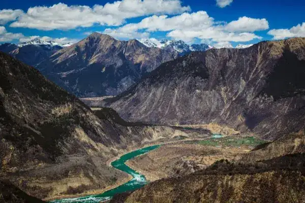
The terrain features high mountains in the south (Himalaya, averaging 6,000+ meters) and valleys with the Yarlung Tsangpo and Nyenchu rivers. Five peaks exceed 8,000 meters: Mount Everest (8,848.86 m), Lhotse (8,516 m), Makalu (8,463 m), Cho Oyu (8,201 m), and Shishapangma (8,012 m), plus 14 peaks above 7,000 meters. The river valley plains have gentle slopes, deep soil, and sufficient water.
Climate
Three climate zones: plateau temperate semi-arid monsoon (north of Himalaya, south of Gangdise-Nyenchen Tanglha), plateau sub-frigid monsoon semi-arid (north of Gangdise), and plateau temperate monsoon semi-humid (south of Himalayan crest). Annual average temperature: 6.3°C (0°C in northwest, 6.5°C in east). Annual sunshine: 3,300 hours. Annual precipitation: 200–430 mm (east), less than 200 mm (northwest), about 1,000 mm (south slopes). 90% of precipitation falls May–September, with 70–80% as nighttime rain. Frost-free period: 120+ days.
Hydrology
100+ rivers. The Yarlung Tsangpo (Tibet's largest river) originates at the Jema Yangzong Glacier in Zhongba County, flowing 700 km through 10 counties. The Nyenchu River originates in Kangmar County and joins the Yarlung Tsangpo at Xigaze. Other rivers include the Peng Qu, Daxung Tsangpo, and Zhong Qu. Most belong to the Indian Ocean system, fed by groundwater, rain, and snow melt, with low temperature and low sediment.
Natural Resources
Land Resources
Land area: 17.6 million hectares. Cultivated land: 79,500 hectares, mainly in river valleys. Grassland: 12.7581 million hectares (10.9316 million usable). Forest: 1.228 million hectares with 32.5676 million cubic meters of standing timber. Forest coverage: 6.81%.
Plant Resources
Tree species include Himalayan fir, Himalayan spruce, birch, and Tibetan larch. Rare species include long-leaf spruce, hemlock, Himalayan yew, and cedar. 300+ medicinal plant species including Fritillaria, codonopsis, Cordyceps, Gastrodia, snow lotus, astragalus, and rhubarb.
Animal Resources
Domestic animals: yak, cattle, dzo, horse, donkey, goat, sheep, pig, chicken. Wildlife: red panda, langur, wild boar, brown bear, leopard, macaque, snow leopard, blue sheep, wild yak, Tibetan wild ass, Tibetan antelope, argali, fox, lynx, marmot, black-necked crane, Tibetan snowcock, vulture, and 200+ bird species. Wild yak, wild ass, Tibetan antelope, snow leopard, and black-necked crane are Class I national protected species.
Mineral Resources
234 mineral occurrences with 46 types including gold, silver, zinc, lead, lithium, antimony, mercury, copper, iron, chromium, boron, mica, salt, and crystal. Borax reserves are significant. Main mined minerals: gold, copper, lead, zinc, chromium, antimony, jade, boron, mineral water, and granite.
Population
Population Size
According to the Seventh Census (November 1, 2020): 798,153. As of end 2024: 814,500 (urban 203,600, 25%; rural 610,900, 75%).
Ethnic Composition
Predominantly Tibetan, with Han, Hui, Mongolian, Tujia, Manchu, Miao, Zhuang, and dozens of other ethnic groups.
Politics
Economy
Overview
In 2025, the gross regional product was 50.987 billion yuan, up 7.6%. In 2024: 46.43 billion, up 6.4%. By industry: primary 7.578 billion, up 13%; secondary 13.658 billion, up 7.1%; tertiary 25.194 billion, up 4.3%. Structure: 16.3:29.4:54.3. Per capita GDP: 57,531 yuan. Total retail sales: 18.789 billion, up 5.2%. Rural per capita disposable income: 21,231 yuan, up 7.9%. Construction output: 6.964 billion, up 79.5%.
Primary Industry
Total agricultural output: 9.947 billion yuan, up 13.1%.
Secondary Industry
Above-scale industrial added value up 16.9% in 2024.
Tertiary Industry
Total retail sales (2024): 17.863 billion yuan, up 7%. Foreign trade (2023): 5.422 billion yuan, up 41.6x (exports 5.351 billion, up 41.2x). Total deposits (2023): 60.999 billion, down 8.2%. Total loans: 41.721 billion, up 23.7%. Insurance premiums: 749 million, up 11.1%.
Social Affairs
Science and Technology
6 regional S&T projects, 10 million yuan in funding. 1 autonomous region makerspace (49 incubated companies). 2 national "Star Innovation" bases. 6 high-tech enterprises, 25 technology-based SMEs.
Education
1,045 schools, 190,768 students. 2 secondary vocational (6,945), 34 secondary schools (17,885 high school, 36,475 junior high), 229 primary (89,312), 1 special education (206), 779 kindergartens (39,945). Preschool gross enrollment: 90.3%. Primary enrollment: 100%. Junior high enrollment: 109.9%. High school enrollment: 91.6%.
Culture
19 cultural centers/stations, 206 township cultural stations, 1 professional art troupe, 18 county art troupes. 18 broadcasting stations. Radio coverage: 99.5%, TV coverage: 99.7%.
Healthcare
266 health institutions: 35 hospitals, 202 health centers, 19 CDCs, 6 maternal/child centers, 2 community health centers. 3,883 beds. 5,189 health workers.
Sports
Primary school sports area: 1.046 million square meters. Secondary school sports area: 498,000 square meters.
Social Security
Urban-rural pension: 460,200. Employee medical: 74,800 (99.0%). Urban-rural medical: 717,800 (98.35%). Enterprise pension: 33,700. Government pension: 41,900. Work injury: 70,300. Unemployment: 52,400. Urban minimum living: 2,842 (25.7763 million yuan). Rural minimum living: 19,888 (52.402 million yuan). Disability subsidies: 12,065 (living) + 8,246 (care). 24 social welfare institutions (18 county-level, 4 township, 2 children's). 1,740 supported persons. 761 children's beds.
Transportation
Overview
In 2023: passengers 2.3948 million (up 72.7%, highway 979,000, railway 1.2959 million, aviation 119,900). Freight 11.8255 million tons (up 24.1%, highway 11.425 million, railway 400,100, aviation 400). Total highway mileage: 21,530.78 km (34.87 km high-grade, 16,046.42 km rural). 197 townships with asphalt roads, 1,500 villages accessible.
Aviation
Xigaze Peace Airport opened July 8, 2011 (flights to Chengdu on Mon/Wed/Fri/Sun). Xigaze Tingri Airport opened December 24, 2022.
Railways
Xigaze Station opened August 15, 2014, connecting to Lhasa in 3 hours. Future plans include railways to Gyirong Port and Yadong Port, potentially forming an international rail corridor to Nepal and India.
Highways
Total mileage: 21,600 km, including 15,800 km rural. National Highway 318, Provincial Highways 203 and 304 traverse the city. 197 townships with asphalt roads, 1,408 villages accessible.
History and Culture
Handicrafts
Traditional crafts include "Somba" boots, Gyangze carpets, gold and silverware, woolen fabrics, Tibetan clothing, Xaitongmoin and Lhaze Tibetan knives, Rinbung jade, and Gyirong wooden bowls.
Folk Dance
Xigaze is known for its rich dance traditions. "Gorshe" is lively and grand; "Sima Drok" drumming is bold and passionate; Gyirong's conch dance is graceful; the "Cham" religious dance features 80 monks in costume with masks of Buddhist guardian deities. The annual Cham festival (8th Tibetan month) has a 200–300 year history.
Tibetan Opera
Tibetan Opera ("Achi Lhamo") originated in the 15th century when the Kagyu monk Tangtong Gyalpo formed a troupe of seven sisters to raise funds for bridge construction. Major works include "Princess Wencheng and the Nepalese Princess," "Nangsa Wonbum," "Sukyi Nyima," "Drowa Sangmo," "Norsang," "Pema Wabar," and others.
Traditional Festivals
Tibetan New Year: The most important festival, celebrated both as the "Farmers' New Year" (12th Tibetan month, 1st day) and the standard Tibetan New Year (1st Tibetan month, 1st day).
Lingka Festival: May 1–15 (Tibetan calendar), when people picnic in parks and forests.
Dama Festival: Horse racing and archery, originally in Gyangze, now held during agricultural off-season in June.
Bathing Festival: When the planet Venus appears for 7 days (mid-7th Tibetan month), families go to rivers and springs to bathe, believed to have eight healing virtues.
Ongkor Festival: Pre-harvest celebration where villagers circumambulate fields with incense, prayer flags, and scriptures, calling for blessings and harvest, followed by horse racing, yak racing, opera, and dancing.
Bullfighting Festival: Held in Bainang County in August, with bulls competing from each village.
Scenic Spots
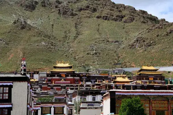
Mount Everest and the Everest Nature Reserve in Tingri County. Tashilhunpo Monastery (symbol of Xigaze, seat of the Panchen Lamas). Baiju Monastery in Gyangze ("King of Pagodas"). Sakya Monastery. The Zongshan Anti-British Site. The six famous valleys on the southern slopes of the Himalayas: Yadong Valley, Chentang Valley, Kama Valley, Rongxia Valley, Zham Valley, and Gyirong Valley, collectively known as "Little Jiangnan of Tibet."
Honorary Titles
Second batch National Historical and Cultural City (1986). National Ethnic Unity and Progress Demonstration City (2019). National Double Support Model City (2020, 2025). Fourth batch National Public Culture Service System Demonstration Zone (2021). Seventh batch Ecological Civilization Construction Demonstration Zone (2023). China Border Characteristic Tourism Charm City (2025). National Cross-border Trade Facilitation Pilot City (2026).
Travel information can change. Check current opening hours, reservations and entry requirements before you travel.
Traveller discussion
Start the conversation with a helpful tip or a question.