
Daxinganling
DaxinganlingDaxinganling Prefecture is China's northernmost and highest-latitude prefecture-level administrative division, under Heilongjiang Province. Located on the northeast slope of the Greater Khingan Mountains, it covers 83,000 square
Daxinganling
Daxinganling Prefecture is China's northernmost and highest-latitude prefecture-level administrative division, under Heilongjiang Province. Located on the northeast slope of the Greater Khingan Mountains, it covers 83,000 square kilometers spanning Heilongjiang Province and Inner Mongolia. The administrative office is in Jiagedaqi District. As of May 2026, it administers 4 districts, 1 county-level city, and 2 counties. As of the end of 2025, the registered population was 357,584. The climate is cold-temperate continental monsoon with extreme temperature variations; aurora borealis occasionally appears around the summer solstice. The area has been inhabited since the Paleolithic Age. In 1964, a special zone was established; in 1970, it became a prefecture. As a key national forest area, it houses China's only remaining cold-temperate bright coniferous forest zone. In 2025, GDP was 17.75 billion yuan (approximately US$2.5 billion), up 4.2%. Known for the "Shenzhou North Pole" brand, it features the Beiji Village 5A scenic area and multiple national nature reserves.
Historical Evolution
The area was historically inhabited by the Donghu tribal alliance (pre-Qin), Xianbei (Three Kingdoms-Jin), and Shiwei (Sui-Tang). During the Yuan dynasty, Genghis Khan enfeoffed the lands to his brothers. The Qing dynasty established gold mining stations, creating the "Gold Road" of northern China. In 1964, the CPC Central Committee established a campaign headquarters to develop the area. In 1970, it became Daxinganling Prefecture. In 2020, the Daxinganling Forestry Group was established, ending 56 years of integrated government-enterprise management.
Administrative Divisions
As of May 2026, the prefecture administers 4 districts (Jiagedaqi, Songling, Xinlin, Huzhong), 1 county-level city (Mohe), and 2 counties (Huma, Tahe). The administrative office is at No. 1 Landscape Avenue, Jiagedaqi District. Note: The four districts are not standard national administrative divisions; Jiagedaqi and Songling land rights belong to Inner Mongolia.
Physical Geography
Location and Boundaries
Located between 50°07′–53°33′N and 121°10′–127°01′E, it is China's northernmost region, bordering Russia along the Heilongjiang (Amur) River (786 km border). Total area: 83,000 km² (78.1% in Heilongjiang, 21.9% in Inner Mongolia).
Topography and Landforms
The terrain consists of mid-level mountains, low mountains, hills, and intermountain basins. Average elevation is 573 m; highest peak is Dabaishan (1,528 m) in Huzhong District; lowest is 180 m at Huma County. The Yilehuli Mountains run east-west across the region, serving as the watershed between the Heilongjiang and Nenjiang river systems.
Climate
The region has a cold-temperate continental monsoon climate. Average annual temperature is −4°C (Mohe and northern Huzhong) to −2°C elsewhere. The frost-free period is 80–110 days. Extreme minimum: −53°C (January 2023); extreme maximum: 40.5°C (June 2010). Average annual precipitation is 460 mm, concentrated July–September.
Hydrology
The area has 28 rivers with catchment areas exceeding 1,000 km², including the Huma, Emur, and Pangu rivers, plus the international Heilongjiang River. Total river length: 4,410 km.
Natural Resources
Water Resources
Total water resources: 15.339 billion cubic meters/year. Per capita water is 31,308 m³—12 times the national average and 3 times the world average. Theoretical hydropower reserve: 780,400 kW.
Plant Resources
Over 900 species of vascular plants across 92 families, including 342 medicinal species (astragalus, gentian, etc.), 42 edible species (blueberries, ferns, mushrooms), and 28 oil-bearing species.
Animal Resources
250 bird species (including black-billed capercaillie and hazel grouse), 56 mammal species (including sable, wolverine, brown bear, moose), 43 fish species (including chum salmon, sturgeon, and taimen), and 7 amphibian and reptile species. National Class I protected species include sable, wolverine, and musk deer.
Mineral Resources
Over 40 mineral varieties with 584 occurrences. Gold reserves: 175 tons (placer gold accounts for 60.26% of Heilongjiang's total). Iron ore: 18.196 million tons. Other minerals include copper, lead, zinc, molybdenum, marble, and bentonite.
Population
Population Size
The 2020 census recorded 331,276 residents—a 35.24% decrease from 2010. As of the end of 2025, the registered population was 357,584, with a birth rate of 2.04‰, death rate 20.70‰, and natural growth rate −18.66‰.
Ethnic Composition
29 ethnic minorities including Manchu, Mongol, Daur, Oroqen, Ewenki, and Russian. The Oroqen are indigenous, mainly residing in Shibazhan (Tahe County) and Baiyina (Huma County).
Politics
Economy
Overview
In 2025, GDP was 17.75 billion yuan (approximately US$2.5 billion), up 4.2%. The industrial structure was 27.7:8.3:64.0 (primary:secondary:tertiary). General public budget revenue was 1.5 billion yuan (up 0.4%). Fixed asset investment grew 7.4%.
Primary Industry
Total agricultural, forestry, animal husbandry, and fishery output was 9.88 billion yuan (up 4.0%). Grain output was 280,000 tons (soybeans 212,000 tons, wheat 40,000 tons, corn 23,000 tons). Meat production was 11,000 tons.
Secondary Industry
Above-scale industrial added value decreased 0.5%. Key products: fruit wine 305.7 kiloliters, juice 6,845 tons, cement 71,642 tons, and coal 1.835 million tons. Construction output was 680 million yuan.
Tertiary Industry
Total retail sales of consumer goods reached 4.11 billion yuan (up 5.0%). Total import-export was 170 million yuan (up 110.3%). Financial institution deposits reached 60.57 billion yuan and loans 21.01 billion yuan. Insurance premium income was 1.36 billion yuan (up 11.2%).
Social Affairs
Science and Technology
18 high-tech enterprises and 79 technology-based SMEs. 101 patents granted, with 93 valid invention patents.
Education
23 middle schools, 13 primary schools, and 28 public kindergartens. Daxinganling Vocational College enrolled 2,077 students.
Culture
1 art troupe, 8 cultural centers, 8 public libraries, 8 museums. Radio and TV coverage both 100%.
Healthcare
266 health institutions including 35 hospitals, with 2,827 beds and 3,551 health personnel.
Sports
Athletes won 27 medals at provincial competitions (13 gold, 3 silver, 11 bronze).
Social Security
Enterprise pension insurance covered 107,000 people. Medical insurance covered 329,000. Unemployment insurance covered 73,000.
Transportation
Overview
Daxinganling is the only prefecture in Heilongjiang without expressway access. Road network density is 9.04 km/100 km². In 2025, highway passengers totaled 7.11 million (down 14.2%) and air passengers 511,000 (up 12.4%).
Highways
Major routes include the Nenmo Highway and National Highway G111. Total road mileage reached 7,226 km. The prefecture operates 31 bus routes with 149 buses.
Railways
Jiagedaqi Station, operational since 1969, is the intersection of the Nenlin and Yijia railways, serving as a Class I passenger and freight station.
Water Transport
5 water passenger transport enterprises operate 22 vessels with 1,028 seats on 5 tourist routes along the Heilongjiang River, carrying 221,000 passengers in 2025.
Aviation
The prefecture has 3 airports: Daxinganling Oroqen Airport (4C, serving Beijing, Shanghai, Harbin), Mohe Gulian Airport (China's northernmost airport, built on permafrost, 4C), and Huma Luding Mountain Airport (2B general aviation, opened 2024).
Scenic Spots
The prefecture has 8 national nature reserves (Huzhong, Nanwenghe, Shuanghe, etc.) totaling 981,100 hectares, 4 provincial reserves, 4 national forest parks, 1 internationally important wetland (Nanwenghe), and 10 national wetland parks.
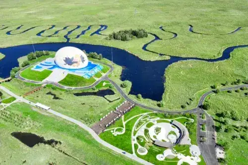
Key attractions: Yakesa Ancient Battlefield (visible fortifications in Mohe), Li Jinlong Shrine (commemorating the founder of the Laogou Gold Mine), Yanzhi Gully (Rouge Gully, famous for gold deposits), Shenzhou North Pole (Beiji Town, the northernmost settlement in China with "northernmost" themed landmarks), Dabaishan (highest peak at 1,528.7 m), and Wu Balao Island (three sand islands in the Heilongjiang River).
Notable Figures
Chi Zijian: Renowned author from Beijicun, Mohe. Zhu Hong: Calligrapher and World UNESCO member. Zhang Yi: Former Daxinganling Party Secretary and former SASAC Director.
Honorary Titles
Listed in China's Top Summer Resort Cities (2020). Designated a National Ecological Civilization Construction Demonstration Zone (2023).
Travel information can change. Check current opening hours, reservations and entry requirements before you travel.
Traveller discussion
Start the conversation with a helpful tip or a question.